Publication Case study
Columbia River Levees at Vanport (Oregon, 1948)
Case study. Association of State Dam Safety Officials, Dam Failures and Lessons Learned (damfailures.org), 2018.
- Author
- Meghan Walter
- Year
- 2018
- Topics
- Failure case historiesDam safetyEngineering ethics
- Source
- See the link at the end
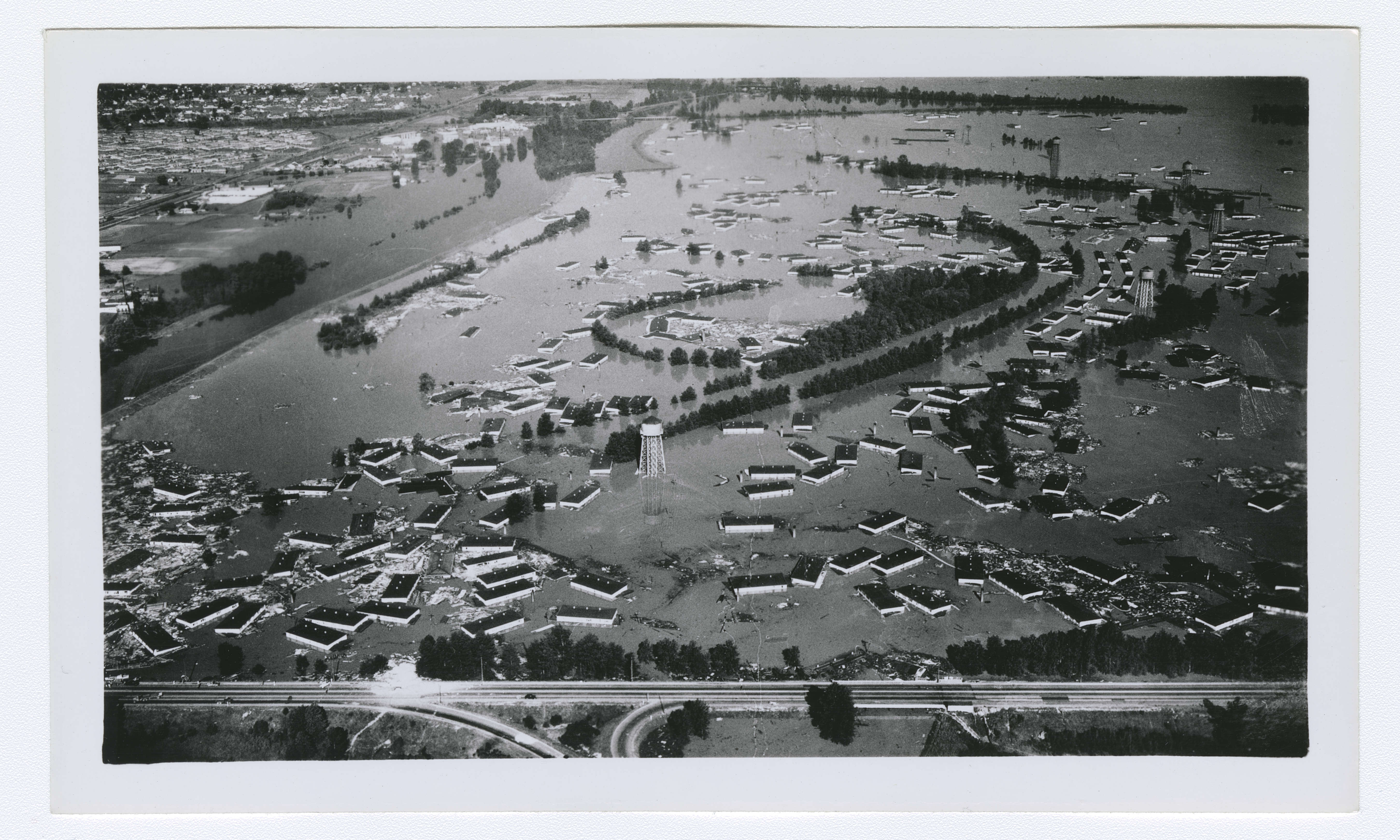
Vanport was built in 1943 on the marshy lowland between the Columbia River and the Columbia Slough, north of Portland, to house shipyard workers. At its wartime peak it held 42,000 people, the largest housing project in the country and Oregon's second city. A 4.9 mile ring of levees stood between it and the river. On the afternoon of Sunday, May 30, 1948, with the Columbia at levels not seen since 1894, the railroad fill on the west side, assumed to be the strongest segment, opened a six-foot hole that grew to 500 feet. The city was gone within hours. At least fifteen people died. The morning bulletin had told residents the dikes were safe.
| Item | Detail |
|---|---|
| Location | Vanport, Oregon, between the Columbia River and Columbia Slough |
| Type | Earthfill levee system: flood wall, slough levee, a railroad fill, and a road embankment |
| Height | 12 to 30 ft |
| Built | Corps of Engineers, 1941; railroad fill 1907 over a trestle filled about 1913 |
| Failed | Sunday, May 30, 1948, 4:17 p.m.; Denver and Union Avenues on May 31 |
| Mode | Internal erosion under extreme flood loading |
| Population | About 18,000 in 1948; 42,000 at the wartime peak |
| Fatalities | 15 confirmed, possibly more |
| Damage | $21.5 million in 1948 dollars; more than 18,000 left homeless |
Background
Henry Kaiser built Vanport in a matter of months in 1943 as private housing for the thousands who came to his Oregon Shipbuilding Corporation during the war. Because it lay outside Portland's limits, a housing authority acted as its unofficial government, with its own fire and school districts and law enforcement from the Multnomah County sheriff. The population fell after the war, but returning service members held it near 18,000 in 1948. It was easily the most diverse community in the state: about 12,600 white residents, 5,000 Black residents, and 900 Japanese Americans.
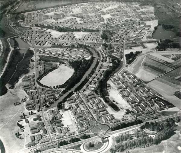
The levee system, called dikes at the time, ran 4.9 miles around 650 acres. The U.S. Army Corps of Engineers completed it in 1941 under the Flood Control Act of 1936 and handed it to Peninsula Diking District No. 1. The Corps built a flood wall along the Columbia to the north and a levee along the slough to the south. The east and west sides were not improved: the Denver Avenue road embankment served as the eastern levee, and on the west an existing fill of the Spokane, Portland and Seattle Railway did the job.
Spring 1948 stayed cold across the Columbia basin into May, then turned hot. Snowmelt that normally began in April started in late May, and two large storms, May 19 to 23 and May 26 to 29, fell on top of it. The tributaries filled and the Columbia rose to heights not seen since the record flood of 1894.
The flood
By Tuesday, May 25, the Columbia and Willamette stood at 23 feet, eight above flood stage. Vanport began round-the-clock patrols of the north and south dikes, and added the railroad fill when Smith Lake rose against it. On Saturday, May 29, the housing authority, Corps engineers, the Red Cross, the sheriff, and other officials met at Red Cross headquarters to discuss evacuation. The authority and the Red Cross could house 9,000 to 10,000 people; Vanport had 18,000, many with no transport but the bus. No decision was made, and another meeting was set for Monday. The record suggests evacuation would have been ordered had anyone believed there was somewhere to put people.
Remember: Dikes are safe at present. You will be warned if necessary. You will have time to leave. Don't get excited.
So ended the bulletin slipped under every door at 4 a.m. on Sunday, May 30. It said the flood situation had not changed, that barring unforeseen developments Vanport was safe, and that any evacuation would be signaled by siren and air horn, with sound trucks giving instructions.
| Time | Event |
|---|---|
| Sun 7:30 a.m. | Fire captain Robert English reports for patrol; crews warned the river is rising fast |
| 9:15 a.m. | Muddy water reported leaking under the railroad fill at the northwest corner, by Vanport College. Sandbagging ordered |
| 9:45 a.m. | Another boil found near Denver Avenue and Cottonwood, at the southwest corner |
| 10:15 a.m. | Railroad fill leak growing worse; 10 to 12 men sent |
| 1:30 p.m. | More men sent; fill still leaking badly. Patrols told there is no immediate danger, and pass that on to callers |
| 3:00 p.m. | Chief engineer orders all fire department personnel back to the station |
| 3:47 p.m. | Corps engineers note Vanport sits 15 ft below the river and Smith Lake |
| 4:17 p.m. | Railroad fill breaks. Six-foot hole grows to a 500 ft gap |
| 4:20 p.m. | Sirens sound; the air horn shorts out in the water. First wave reaches the first houses within a minute |
| 4:50 p.m. | Power fails |
| 5:21 p.m. | Radio station leaves the air; a floating apartment building topples a tower half an hour later |
| 9:00 p.m. | Search crews believe no one is still stranded |
| Mon 9 p.m. | Denver Avenue embankment breaches at the underpass; an emergency vehicle goes into the water, the first confirmed death. Union Avenue breaches afterward |
| Tue Jun 1 | Columbia crests at 30.2 ft |
Captain English and his crew had patrolled in four-hour shifts for two days, told to look for blisters, heavy seepage, muddy water, boils, and strangers on the dikes after dark. A boil at the toe of the south dike and a leak under the north flood wall had already been sandbagged. At 9:15 that morning came the call about muddy water under the railroad fill. English met railroad officials and an engineer from Swift and Company at the spot; sandbagging began on the Vanport side. The leak grew through the day. At intervals, he wrote later, they were still being assured there was no immediate danger, and he passed the same word to the residents who kept calling.
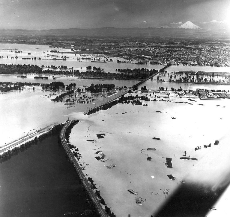
At 4:17 p.m. the fill broke. The hole, six feet across at first, widened to 500 feet. The fill there was 125 feet wide at the base and 75 at the top. Half an hour earlier the army engineers had noted Vanport was 15 feet below the river and Smith Lake. Water from the lake poured in; the first wave hit the first row of houses within a minute of the siren. A ten-foot wave knocked the wooden buildings off their foundations and broke many apart. The sloughs inside the city filled first, which slowed the water and bought residents minutes. Power went out at 4:50. The radio station left the air at 5:21, and half an hour later a floating apartment building brought down one of its towers.
Within an hour Governor John Hall declared a limited emergency and authorized the National Guard to requisition what it needed. The injured were too many to count. Buses came to carry people out, but boats were what was needed, and after the sheriff's call they came quickly. Children were passed from upper windows to boats below; then boats took people from the roofs of the two-story blocks. By 9 p.m. the searchers believed no one was left stranded.
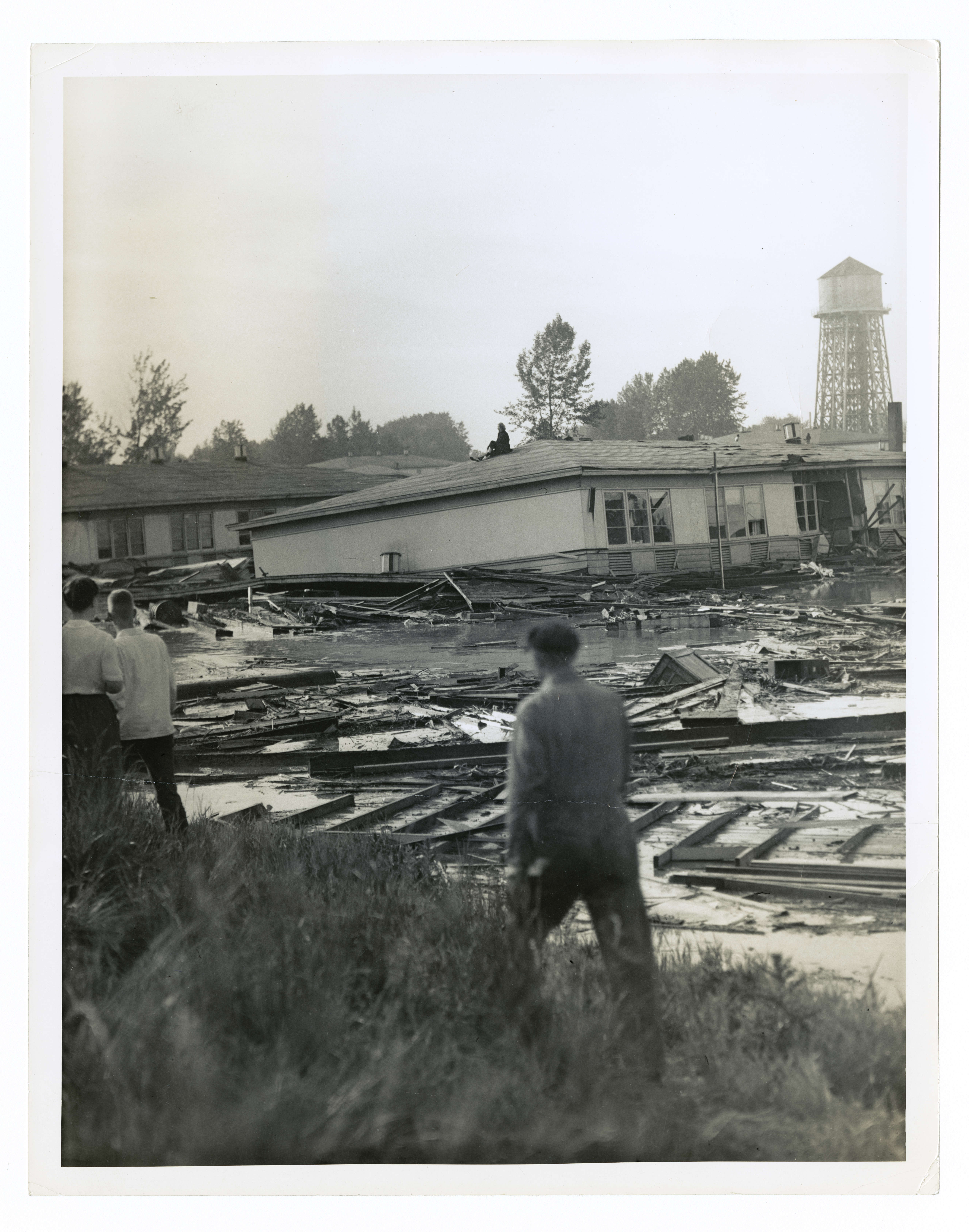
No deaths had been found by Monday morning. That evening the Denver Avenue embankment on the east side became the worry, and just after 9 p.m. it breached at the underpass. An emergency vehicle crossing at that moment went into the water with its driver, the flood's first confirmed death. As the water pushed east, the Union Avenue embankment breached too.
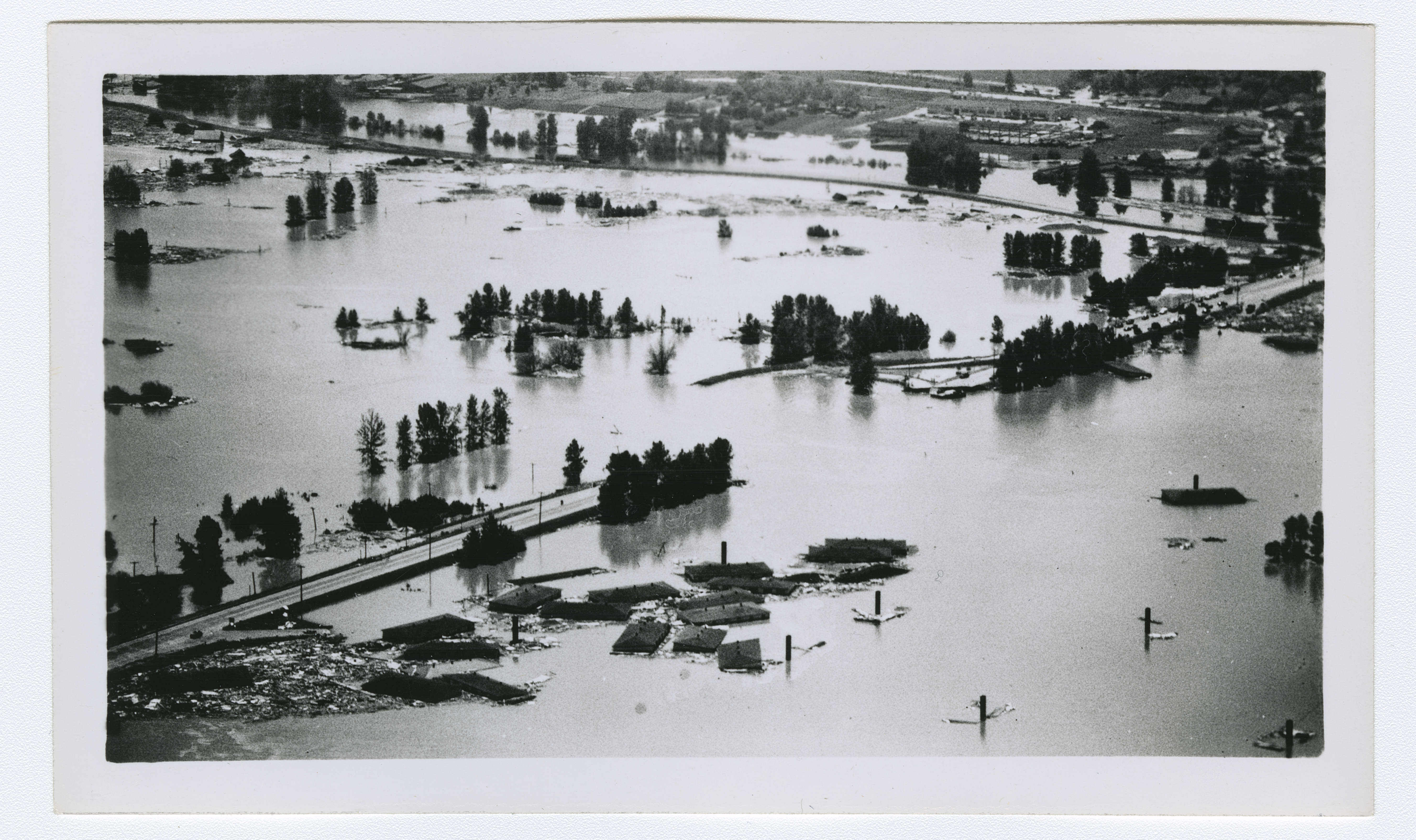
In less than a day the nation's largest housing project was destroyed. More than 18,000 people were homeless and many injured. At least fifteen died, and the state put property loss at $21.5 million. The Columbia crested at 30.2 feet on June 1 and fell so slowly that Vanport stayed under water for weeks. Thirteen bodies had been identified by September 1. The coroner's final count was fifteen, with the acknowledgment that others may never have been found.
Causes and consequences
Within days the newspapers reported that the railroad fill had never been designed or built as a levee. It was a fill placed in 1907 to carry the tracks of the Spokane, Portland and Seattle Railway, and the railway maintained it as track support, not as a dike. Yet it had been considered the strongest part of the system, 40 to 60 feet wide at the top with the most freeboard anywhere on the ring. The Oregonian observed that the failure occurred within the fill because its high freeboard kept the water from going over the top.
An assistant maintenance engineer with the housing authority proposed a cause. The rail line had first crossed the lowland on a wooden trestle, filled in about 1913 with the trestle left inside. The railroad's retired chief engineer doubted the timber had decayed enough to matter; the housing engineer held that the wood had compressed and let the fill move. The railroad fill, and the Denver and Union Avenue embankments after it, appear to have failed by internal erosion under the hydrostatic load of an extreme flood.
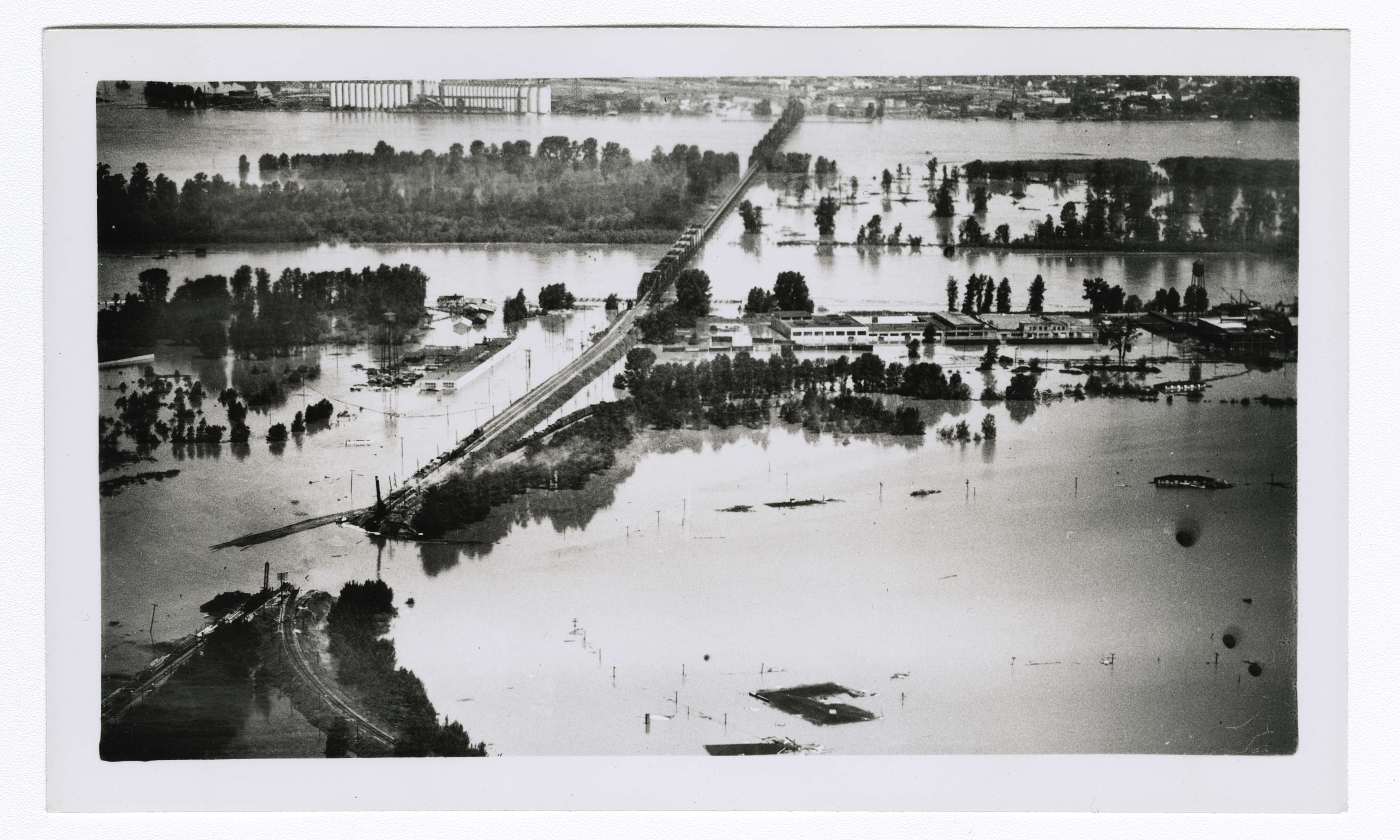
The housing authority's attorney told the press the authority felt terribly bad that lives might have been lost, but that all one could do was rely on competent engineers. The authority and the Corps became the scapegoats; residents filed more than 650 suits for damages. In October 1952 Judge James Alger Fee ruled that the government could not be held liable for flood damage, and every case was lost.
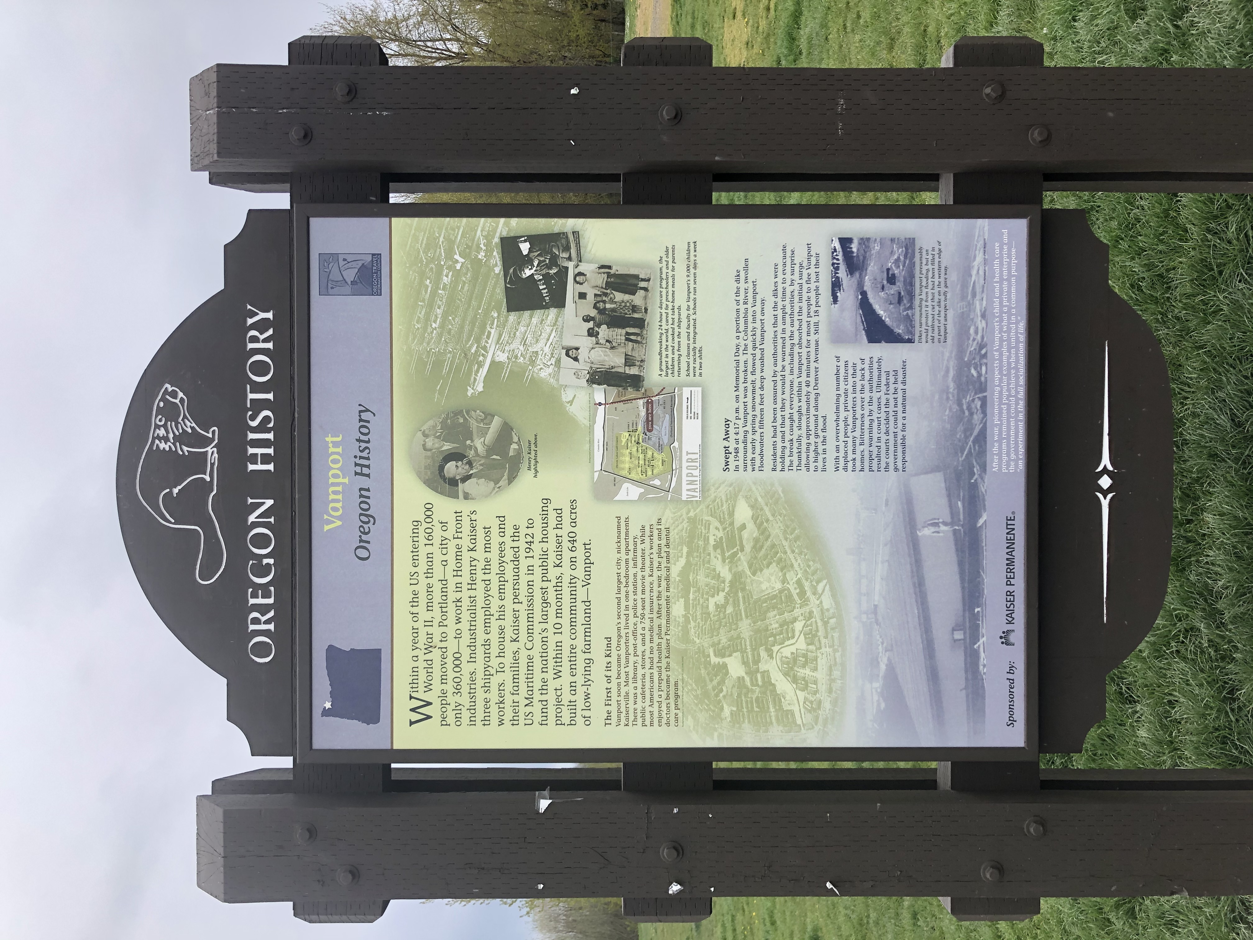
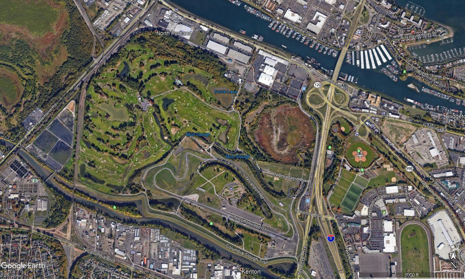
In 1948 the Corps was drafting a comprehensive plan for the Columbia basin built around navigation and power. The flood made the case for flood control, and the plan came to include it. Vanport itself was never rebuilt. The land belongs to the City of Portland and holds a golf course, Portland International Raceway, the Expo Center, and wetlands. Historical markers near the golf course and raceway tell the story of a city washed away in an evening.
Lessons learned
- Timely warning and rapid public response are critical to saving lives during a dam emergency. Because flooding was thought unlikely, little was done to prepare to move 18,000 people, many of whom depended on public transport. With no warning time, residents fled with nothing. The breach came on a pleasant Sunday afternoon of a holiday weekend, and many families were already out, which kept the death toll lower than it might have been.
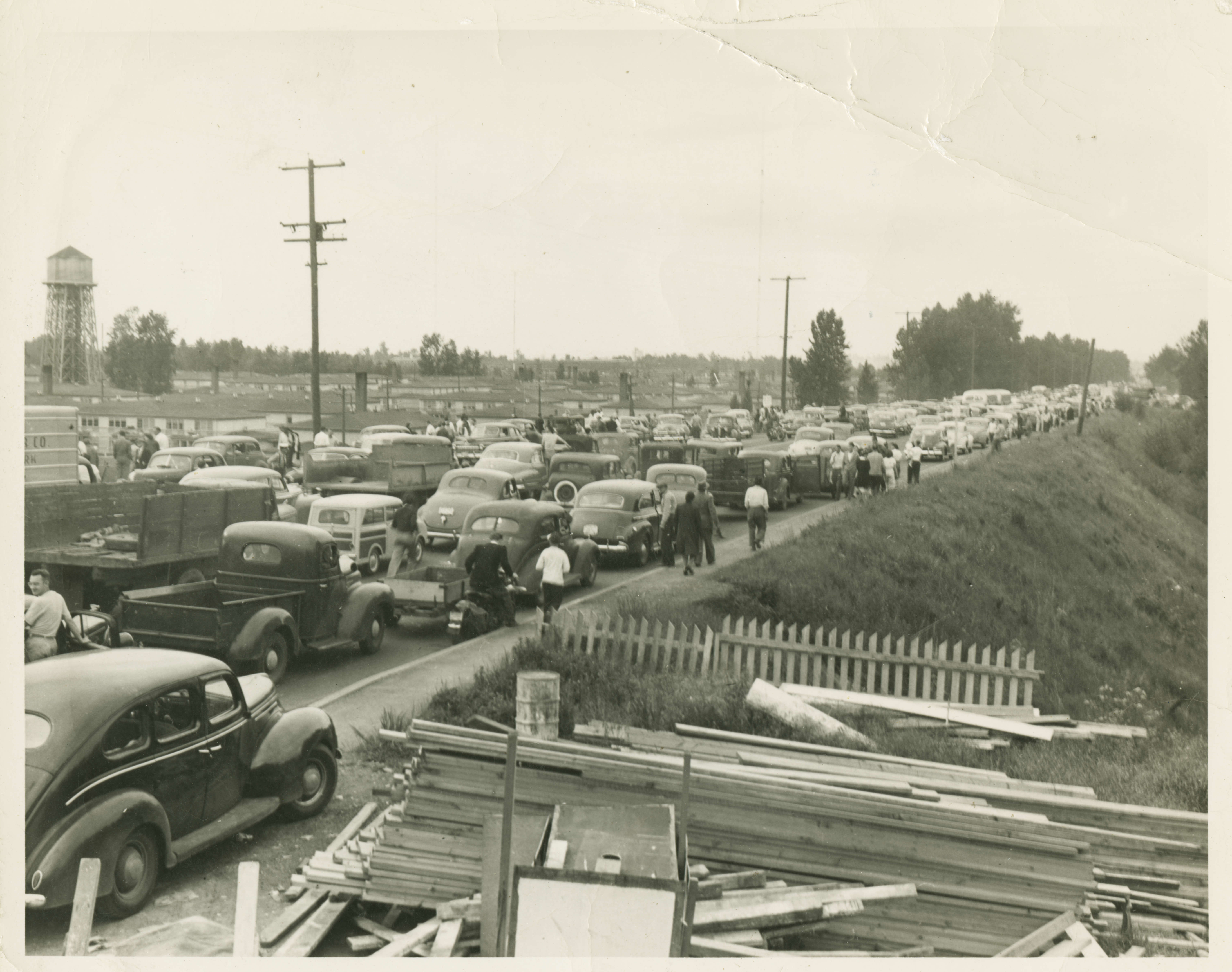
- Emergency Action Plans can save lives and must be updated, understood, and practiced regularly to be effective. Vanport had no comprehensive disaster plan. Traffic clogged the few evacuation routes, two of the failed embankments were themselves the main north-south routes out, the siren system underperformed, and the loss of power and communications forced the authority and the Red Cross to improvise radio operations.
- Dam failure sites offer an important opportunity for education and memorialization. Vanport is gone from the map, but the markers remind visitors of the community and its influence on Portland.
- Regular operation, maintenance, and inspection of dams is important to the early detection and prevention of dam failure. Unclear responsibility for the railroad fill as part of the diking system let many assume it was the strongest segment, when it had never been built to hold water.
- Dam incidents and failures can fundamentally be attributed to human factors. The decision not to evacuate cost lives and belongings. Robert English's account shows the trouble at the railroad fill was first seen about seven hours before it failed and grew worse all day. The failure was probably inevitable; the loss of life could have been reduced or avoided by evacuating early on Sunday afternoon.
- Floods can occur due to unusual or changing hydrologic conditions. A cold spring, a sudden thaw, and two storms in a week produced the highest water in 54 years.
- Land use planning can reduce the consequences of failure. Kaiser built Vanport in haste as temporary housing before long-term flood control existed in the basin, and at the peak 42,000 people lived behind its levees. The decision not to rebuild removed the risk.
Further viewing
- Oregon Experience: Vanport, Oregon Public Broadcasting.
- Vanport Flood: Nothing Left but the Memories, CBS News.
- 70th Anniversary of the Columbia River Dike Failure, Steve Durgin, 2018 ASDSO National Dam Safety Conference.
References
- American Red Cross, Portland-Multnomah County Chapter. (1948). Vanport City flood preliminary disaster report. Multnomah County Library.
- English, R.O. (n.d.). My observations of the Vanport tragedy, the flood. Oregon Historical Society.
- Kahan, J., Wu, M., Hajiamiri, S., and Knopman, D. (2006). From flood control to integrated water resource management: lessons for the Gulf Coast from flooding in other places in the last sixty years. RAND Gulf States Policy Institute.
- Maben, M. (1987). Vanport. Oregon Historical Society Press.
- Oregon Department of Geology and Mineral Industries. (2018). Special Paper 50: Flood risk assessment for the Columbia Corridor drainage districts in Multnomah County, Oregon.
- Abbott, C. (2020). Vanport. The Oregon Encyclopedia.
- The Oregonian. (1948, May 31).
- The Oregonian. (1948, June 1).
- U.S. Geological Survey. (1949). Floods of May-June 1948 in Columbia River Basin. Water Supply Paper 1080.
- Geiling, N. (2015, February 18). How Oregon's second largest city vanished in a day. Smithsonian Magazine.
- Billington, D.P., and Jackson, D.C. (2006). Big Dams of the New Deal Era: A Confluence of Engineering and Politics. University of Oklahoma Press.
This case study was written for the Association of State Dam Safety Officials and peer reviewed by Steve Durgin, P.E., Natural Resources Conservation Service, retired.